Stratfield Saye House - geograph.org.uk - 1420587.jpg
From WhereToday Expounder
File:Stratfield Saye House - geograph.org.uk - 1420587.jpg
No higher resolution available.
Stratfield_Saye_House_-_geograph.org.uk_-_1420587.jpg (640 × 427 pixels, file size: 102 KB, MIME type: image/jpeg)
Summary
| Description |
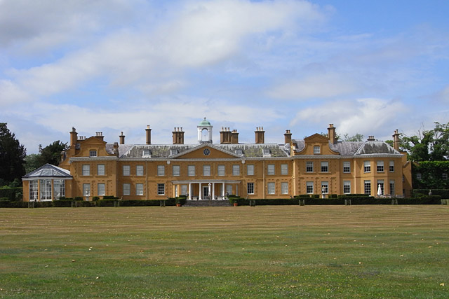
English: Stratfield Saye House The eastern aspect of the house, the nation's gift to the first Duke of Wellington following victory at Waterloo, as seen across lawns that rise gradually from the River Loddon. Most of the house dates from about 1640. The first Duke had the intention of replacing it with a much grander residence elsewhere on the estate. However, funds did not allow for this and instead he had the conservatory and a couple of wings added. These give the house an asymmetrical appearance. |
| Date | |
| Source | From geograph.org.uk |
| Author | Andrew Smith |
| Attribution (required by the licence) | Andrew Smith / Stratfield Saye House / |
| Camera location | | View this and other nearby images on: OpenStreetMap |
|---|
_heading:292.00&language=en-gb)
| Object location | | View this and other nearby images on: OpenStreetMap |
|---|
_heading:292.00&language=en-gb)
Licensing

|
This image was taken from the Geograph GB & Eire project collection. See this photograph's page on the Geograph website for the photographer's contact details. The copyright on this image is owned by Andrew Smith, and is licensed for reuse under the Creative Commons Attribution Share-Alike 2.0 license.
|
This file is licensed under the Creative Commons Attribution-Share Alike 2.0 Generic licence.
Attribution: Andrew Smith
- You are free:
- to share – to copy, distribute and transmit the work
- to remix – to adapt the work
- Under the following conditions:
- attribution – You must give appropriate credit, provide a link to the licence, and indicate if changes were made. You may do so in any reasonable manner, but not in any way that suggests the licensor endorses you or your use.
- share alike – If you remix, transform, or build upon the material, you must distribute your contributions under the same or compatible licence as the original.
File history
Click on a date/time to view the file as it appeared at that time.
| Date/Time | Thumbnail | Dimensions | User | Comment | |
|---|---|---|---|---|---|
| current | 20:35, 1 March 2011 | | 640 × 427 (102 KB) | wikimediacommons>GeographBot | == {{int:filedesc}} == {{Information |description={{en|1=Stratfield Saye House The eastern aspect of the house, the nation's gift to the first Duke of Wellington following victory at Waterloo, as seen across lawns that rise gradually from the River Loddon |
File usage
There are no pages that use this file.