Signal Tower Museum - geograph.org.uk - 1095080.jpg
From WhereToday Expounder
File:Signal Tower Museum - geograph.org.uk - 1095080.jpg
Size of this preview: 400 × 600 pixels. Other resolutions: 160 × 240 pixels | 427 × 640 pixels.
Original file (427 × 640 pixels, file size: 36 KB, MIME type: image/jpeg)
Summary
|
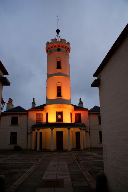
This is a photo of listed building number 21230. |
| Description |
English: Signal Tower Museum Floodlit tower taken from across the courtyard at the entrance to the complex. The buildings to the left and right of the entrance were the original lighthouse keepers houses. The tower and associated buildings are now the museum. The lighthousekeepers houses being used as offices and storage. Unfortunately there is not normally public access to the roof of the tower. |
| Date | |
| Source | From geograph.org.uk |
| Author | Karen Vernon |
| Attribution (required by the licence) | Karen Vernon / Signal Tower Museum / |
| Camera location | | View this and other nearby images on: OpenStreetMap |
|---|
_heading:135.00&language=en-gb)
| Object location | | View this and other nearby images on: OpenStreetMap |
|---|
_heading:135.00&language=en-gb)
Licensing

|
This image was taken from the Geograph GB & Eire project collection. See this photograph's page on the Geograph website for the photographer's contact details. The copyright on this image is owned by Karen Vernon, and is licensed for reuse under the Creative Commons Attribution Share-Alike 2.0 license.
|
This file is licensed under the Creative Commons Attribution-Share Alike 2.0 Generic licence.
Attribution: Karen Vernon
- You are free:
- to share – to copy, distribute and transmit the work
- to remix – to adapt the work
- Under the following conditions:
- attribution – You must give appropriate credit, provide a link to the licence, and indicate if changes were made. You may do so in any reasonable manner, but not in any way that suggests the licensor endorses you or your use.
- share alike – If you remix, transform, or build upon the material, you must distribute your contributions under the same or compatible licence as the original.
File history
Click on a date/time to view the file as it appeared at that time.
| Date/Time | Thumbnail | Dimensions | User | Comment | |
|---|---|---|---|---|---|
| current | 15:17, 24 February 2011 | | 427 × 640 (36 KB) | wikimediacommons>GeographBot | == {{int:filedesc}} == {{Information |description={{en|1=Signal Tower Museum Floodlit tower taken from across the courtyard at the entrance to the complex. The buildings to the left and right of the entrance were the original lighthouse keepers houses. Th |
File usage
There are no pages that use this file.