Dark Lane Quarry (geograph 3671234).jpg
From WhereToday Expounder
File:Dark Lane Quarry (geograph 3671234).jpg

Size of this preview: 800 × 549 pixels. Other resolutions: 320 × 219 pixels | 640 × 439 pixels | 1,024 × 702 pixels | 1,280 × 878 pixels | 1,600 × 1,097 pixels.
Original file (1,600 × 1,097 pixels, file size: 817 KB, MIME type: image/jpeg)
.jpg)
Summary
| Description |
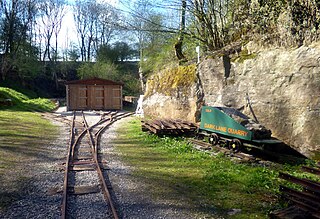
English: Dark Lane Quarry. One of several quarries once served by a branch of the High Peak Railway. The track is now used by the Steeple Grange Light Railway and Dark Lane Quarry is the site of their engine shed. |
| Date | |
| Source | From geograph.org.uk |
| Author | Des Blenkinsopp |
| Permission (Reusing this file) |
Creative Commons Attribution Share-alike license 2.0 |
| Attribution (required by the licence) | Des Blenkinsopp / Dark Lane Quarry / |
| Camera location | | View this and other nearby images on: OpenStreetMap |
|---|
.jpg¶ms=053.096394_N_-001.574498_E_globe:Earth_type:camera_source:geograph-osgb36(SK28595555)_heading:315.00&language=en-gb)
| Object location | | View this and other nearby images on: OpenStreetMap |
|---|
.jpg¶ms=053.096760_N_-001.575090_E_globe:Earth_class:object_type:object_source:geograph-osgb36(SK28555559)_heading:315.00&language=en-gb)
Licensing

|
This image was taken from the Geograph GB & Eire project collection. See this photograph's page on the Geograph website for the photographer's contact details. The copyright on this image is owned by Des Blenkinsopp, and is licensed for reuse under the Creative Commons Attribution Share-Alike 2.0 license.
|
This file is licensed under the Creative Commons Attribution-Share Alike 2.0 Generic licence.
Attribution: Des Blenkinsopp
- You are free:
- to share – to copy, distribute and transmit the work
- to remix – to adapt the work
- Under the following conditions:
- attribution – You must give appropriate credit, provide a link to the licence, and indicate if changes were made. You may do so in any reasonable manner, but not in any way that suggests the licensor endorses you or your use.
- share alike – If you remix, transform, or build upon the material, you must distribute your contributions under the same or compatible licence as the original.
File history
Click on a date/time to view the file as it appeared at that time.
| Date/Time | Thumbnail | Dimensions | User | Comment | |
|---|---|---|---|---|---|
| current | 13:32, 7 June 2018 | | 1,600 × 1,097 (817 KB) | wikimediacommons>Chris j wood | Transferred from geograph.co.uk using [https://tools.wmflabs.org/geograph2commons/ geograph2commons] |
File usage
There are no pages that use this file.
.jpg)